Introduction
© A14C2H courtesy of MOLA Headland Infrastructure
This is a child collection of the main A14 Cambridge to Huntingdon archaeological project archive. For the purposes of analysis, the various Targeted Excavation Areas (TEAs) that formed the mitigation work have been grouped into eight Landscape Blocks.
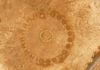
This child collection concerns the Alconbury Landscape Block. Alconbury comprised four TEAs (2, 3, 4, 5) covering 7.2 hectares spread over 1.5km to the west of the Alconbury Book. It forms the western-most block of land of the A14 excavations. The earliest significant archaeological remains comprised a Neolithic henge monument in TEA 2, while the next major phase of activity comprised concentrated middle to late Iron Age settlement at TEA 5 associated with major linear boundaries. Possible transitional late Iron Age to early Roman and early and late Roman settlement activity was excavated at TEA 4, which flanked concentrated areas of presumably Roman settlement revealed by the geophysical survey. This many have been part of a larger nucleated settlement. Extensive middle Roman activity was found at TEA 5 in the area of the earlier Iron Age settlement, seemingly representing the edge of a larger settlement which continued to the east. Activity at TEA 5 persisted into the late Roman period, with a so-called ‘dark earth’ deposit representing the final phase of activity in this area. Occupation of Anglo-Saxon date was evidenced by a single sunken-featured building (SFB) at TEA 2 near to the henge monument.