
The Bosworth Battlefield Project
The Battlefields Trust, 2013. https://doi.org/10.5284/1019859. How to cite using this DOI
Data copyright © The Battlefields Trust, Leicestershire County Council unless otherwise stated
This work is licensed under the ADS Terms of Use and Access.

Primary contact
Dr
Glenn
Foard
Reader in Battlefield Archaeology
Music, Humanities and Media
University of Huddersfield
Queensgate,
Huddersfield
HD1 3DH
England
Tel: 01604 505135
Resource identifiers
- ADS Collection: 1114
- DOI:https://doi.org/10.5284/1019859
- How to cite using this DOI


Downloads
Project Reports
|
Foard, G. 2005: Bosworth Battlefield. A Reassessment. | 12 Mb | |

|
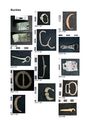
Bosworth Battlefield Survey Small Finds report. | 256 Kb | |
|
Bosworth Battlefield Survey Small Finds report - illustrations. | 2 Mb | |
|
Masters, P. 2008: Geophysical Survey at Bosworth Battlefield, Shenton, Leicestershire. Cranfield Forensic Institute Report No. 018. | 2 Mb | |
|
Partida, T. and Foard, G. 2009: Bosworth Battlefield Survey: Post Medieval Historic Mapping Report. | 4 Mb | |
|
Page, M. 2006: Report on the documentary sources for the reconstruction of the historic landscape of Bosworth battlefield. | 4 Mb | |
|
Curry, A. and Dickinson, J. (with contributions by Professor John McGavin and Michael Bletzer): Report on Military history for the Bosworth Battlefield Association. | 7 Mb | |
|
Hall, D. 2007: Survey of the open-fields for the Bosworth Battlefield Survey (with an addendum on documentary evidence). | 171 Kb | |
|
Gearey, B., Hill, T., Howard, A. and Marshall, P. 2008: Bosworth Fields, Leicestershire: Palaeoenvironmental Survey and Assessment. | 1 Mb | |
|
Wheeler, J and Swindles, G. 2009: Finding Bosworth Field A multiproxy stratigraphic and palaeoenvironmental assessment of lowland sediments from the proposed site of Bosworth Battlefield, Leicestershire. | 776 Kb | |
|
Cox, B. 2009: Bosworth battlefield: Notes on Associated Toponyms. | 4 Mb | |

|
Transcripts and translations of the primary sources relating to the battle of Bosworth. | 4 Mb | |
|
Foard, G. 2005: Bosworth Battlefield Investigation Project Design. | 22 Mb | |
|
Burton, R. 2006: Bosworth Field Investigation Soil Survey Report. | 16 Mb | |
|
Burton, R. 2009: Bosworth Field Investigation Additional Soil Survey Reports 2007 & 2008 & 2009. | 437 Kb |
GIS Files
The zip files are the ESRI shapefiles (.shp, .shx, .prj, and .dbf). These should be used in conjunction with the two metadata files provided below.
| GIS Project Documentation | 156 Kb | |
| GIS File Metadata | 216 Kb |
| MASTER BOS FINDS DATA point | ZIP | 199 Kb |
| MASTER BOS FINDS DATA polyline | ZIP | 1 Kb |
| MASTER BOS FINDS DATA rectangle | ZIP | 1 Kb |
| MASTER BOS FINDS DATA region | ZIP | 224 Kb |
| MASTER BOS FINDS DATA text | ZIP | 1 Kb |
| Master Detecting Day Areas region | ZIP | 97 Kb |
| Enclosed land use ellipse | ZIP | 1 Kb |
| Enclosed land use polyline | ZIP | 5 Kb |
| Enclosed land use rectangle | ZIP | 1 Kb |
| Enclosed land use region | ZIP | 829 Kb |
| Enclosed landscape ellipse | ZIP | 3 Kb |
| Enclosed landscape polyline | ZIP | 17 Kb |
| Enclosed landscape rectangle | ZIP | 2 Kb |
| Enclosed landscape region | ZIP | 524 Kb |
| Enclosed landscape text | ZIP | 1 Kb |
| historic administrative unit region region | ZIP | 85 Kb |
| open field land use region | ZIP | 67 Kb |
| open field landscape polyline | ZIP | 344 Kb |
