
The Ancient Saar Project: London-Bahrain Archaeological Expedition
Robert Killick, 2007. (updated 2024) https://doi.org/10.5284/1042738. How to cite using this DOI
Data copyright © Dr Robert Killick unless otherwise stated
This work is licensed under a Creative Commons Attribution 4.0 International License.

Primary contact
Dr
Robert
Killick
Resource identifiers
- ADS Collection: 456
- DOI:https://doi.org/10.5284/1042738
- How to cite using this DOI
Downloads
The digital objects available for download are below. The physical archive has been deposited in the National Museum of Bahrain.
Reports:
 |
Saar Excavation Report 1 The Dilmun Temple at Saar edited by Harriet Crawford, Robert Killick, and Jane Moon |
||
| Full Report | 11 Mb | ||
 |
Saar Excavation Report 2 Early Dilmun Seals from Saar, fragments of art and administration by Harriet Crawford |
||
| Full Report | 6 Mb | ||
 |
Saar Excavation Report 3 The Early Dilmun Settlement at Saar by Robert Killick and Jane Moon |
||
| Full Report | 45 Mb | ||
Images:

|
Bahrain map Early Dilmun sites in Bahrain |
JPG | 53 Kb |

|
Cemeteries The Northern Burial Complex |
JPG | 266 Kb |

|
Double chamber burials Two-tier Early Dilmun burials along the southwestern edge of the Saar mound-field |
JPG | 267 Kb |

|
Honeycomb cemetery Part of the Southern Burial Complex |
JPG | 313 Kb |

|
Middle East map Southwestern Asia |
JPG | 153 Kb |

|
Saar area map Archaeological remains in the Saar area |
JPG | 155 Kb |

|
Settlement limits Location and extent of the Saar settlement |
JPG | 118 Kb |

|
Site aerial The Early Dilmun settlement at Saar from the air, taken in 1993 (S) |
JPG | 272 Kb |

|
Site and eastwards The plain to the east of the settlement (E) |
JPG | 350 Kb |
The Saar Database:
Documentation
| Database Documentation | 54 Kb | |
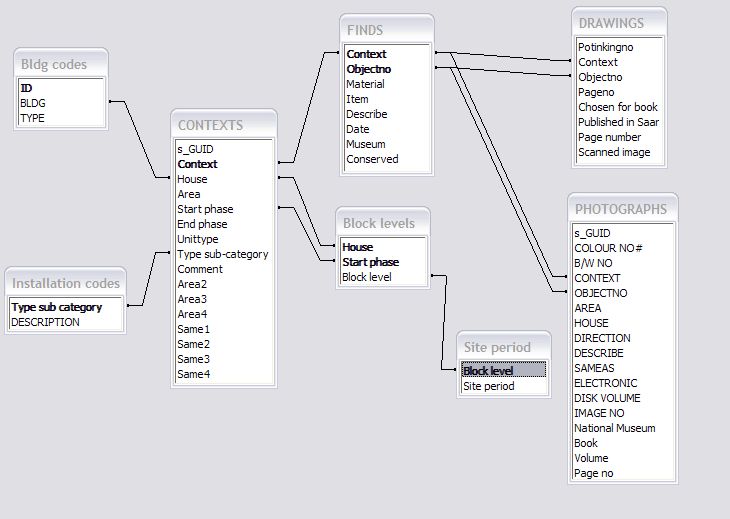
| Entity Relationship Diagram | JPG | 48 Kb |
Database Tables:
| ARCHITECTS PLANS | CSV | 12 Kb |
| SECTIONS | CSV | 20 Kb |
| Block levels | CSV | 6 Kb |
| Room types | CSV | 1 Kb |
| DRAWINGS | CSV | 27 Kb |
| Bldg measurements | CSV | 4 Kb |
| SAMPLING | CSV | 53 Kb |
| Bldg codes | CSV | 1 Kb |
| CONTEXTS | CSV | 730 Kb |
| SITE SUPERVISORS PLANS | CSV | 45 Kb |
| Site period | CSV | 1 Kb |
| FINDS | CSV | 2.08 Mb |
| FILE LIST | CSV | 5 Kb |
| Installation codes | CSV | 1 Kb |
| Pot versus strat | CSV | 5 Kb |
| GRAVES | CSV | 4 Kb |
| PHOTOGRAPHS | CSV | 520 Kb |
| Pottery periods | CSV | 2 Kb |
The Saar Imagebank:
The Imagebank database is available to download below. The Imagebank images can be viewed and downloaded using the Imagebank Search page.
Documentation
| Database metadata | CSV | 2.3 Kb |
| Explanation of fields | 184 Kb |
Database
| Saar Imagebank | CSV | 601 Kb |
GIS Data
Documentation
| GIS Metadata | CSV | 5 Kb |
| GIS Description | 123 Kb |
GIS

PREVIEW |
The Ancient Saar Project GIS - Architecture'Flat' plans of the excavated walls of all the buildings. | ZIP | 0.90 Mb |

PREVIEW |
The Ancient Saar Project GIS - Installations linePlans of the domestic installations (lines) | ZIP | 0.44 Mb |

PREVIEW |
The Ancient Saar Project GIS - Installations polyPlans of the domestic installations (polygons) | ZIP | 3.74 Mb |

PREVIEW |
The Ancient Saar Project GIS - Saar Spot findsLocation of all plotted small finds. | ZIP | 48.04 Kb |

PREVIEW |
The Ancient Saar Project GIS - Contours annotationContours in and around the Saar settlement. | ZIP | 5.27 Kb |

PREVIEW |
The Ancient Saar Project GIS - Contours PolylineContours in and around the Saar settlement. | ZIP | 97.81 Kb |

PREVIEW |
The Ancient Saar Project GIS - CoastOutline of coast of Bahrain as at c.1995. | ZIP | 0.22 Mb |
| The Ancient Saar Project GIS - 2024 GIS Contexts.csv file providing further information about installations. | CSV | 0.29 Mb | |
| The Ancient Saar Project GIS - Catalogue.csv file providing catalogue description of each plotted small find. | CSV | 2.19 Mb | |
| The Ancient Saar Project GIS - Building LevelsThe correlation of levels within and between buildings at Saar, including some revisions to Table 2.2 in Killick & Moon 2005. | XLSX | 12.36 Kb | |
