Using data provided by the ADS for digital archaeological teaching and learning at the University of Vienna
Guest Post By: Dominik Hagmann & Fabiola Heynen
Dominik Hagmann is an university assistant at the Department of Classical Archaeology and lecturer at the Department of Evolutionary Anthropology, Fabiola Heynen is a master’s student in classical archaeology at the University of Vienna.
This is the first in a series of guest posts exploring the re-use of digital data preserved and disseminated by the ADS. This post explores how various data-sets preserved by the ADS are re-used as a teaching resource at the University of Vienna.
Framework
Since 2017 a newly established series of courses at the Departments of Classical Archaeology as well as Evolutionary Anthropology at the University of Vienna want to provide interested students with basic knowledge about digital archaeology in theory and practice. The students acquire first experiences through various practical exercises using and discussing free and open-source software (FOSS) on topics like the application of 3D photogrammetry for the archaeological record or spatial analysis with the help of a geographic information system (GIS).
Since the lessons are held independently at different departments for future classical archaeologists on the one hand and anthropologists on the other hand the conception of the courses must meet the different needs and requirements of a diverse group of undergraduate and graduate students.
Therefore, the scope of the respective course is not exclusively focusing on single periods, such as Roman antiquity, but tries to incorporate varying tasks like mapping and classification of rural settlements or intra site analysis of a Viking-age burial site using QGIS.
Need for Data
Because of this conceptual variety and the content of the courses, there is a special need for relevant archaeological digital data for the students to work with in class as well as at home for self-study. For these requirements the data should be freely accessible in the World Wide Web, well documented, and meet the idea of open science (see e.g. 2016’s Vienna Principles for scholarly communication by Peter Kraker et al.).
The Archaeology Data Service (ADS) and the data collections provided there
by the various contributors meet these requirements and are therefore used regularly for various tasks during the courses. Through its role as an archive for digital heritage data the ADS offers large amounts of diverse archaeological datasets alongside descriptive metadata for the long term which are perfectly suitable to be processed during the courses. Moreover, the rich datasets may be used easily for teaching and learning because of the ADS terms of use and licensing. The comprehensive interface facilitates accessing (i.e. searching, finding, and downloading) the desired data. Additionally, the ADS provides many sustainable examples for the students of how to systematically deal with loads of diverse digital archaeological datasets, for example through a sample citation for the data.
Working with Data
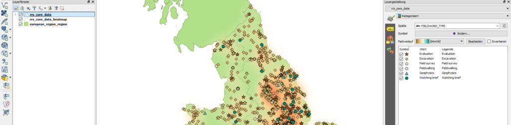
In the 2018/2019’s winter semester the students learned how to use a GIS in archaeology for different tasks in various scales. For example, regarding the first steps in QGIS, the students are introduced to the website of the ADS and the dataset Rural Settlement of Roman Britain by Martyn Allen, Nathan Blick, Tom Brindle, Tim Evans, Michael Fulford, Neil Holbrook, Lisa Lodwick, Julian D Richards, and Alex Smith. Starting with simple tasks like downloading selected files, the students on a beginner level, were introduced to the matter in small steps – during which they appreciated the useful feature of the content’s preview before downloading.
The didactic approach of flipping the classroom was used to initially introduce the students to the datasets available via the ADS and applied methods, as well as to discuss problems they encountered while processing the data at home. Thanks to the metadata provided, like the entity-relationship diagram of the project’s database, the students understood the structure of the datasets provided by the ADS and, moreover, repeated the teaching and learning content from class at home.
Sophisticated software like QGIS offers a lot of opportunities and features. However, while impressive can be confusing at the same time, especially for beginners. Therefore, the contents of the deposit helped them to understand the origins and structure of the data and supported them to focus on their scope of work instead of spending time on gathering data for themselves.
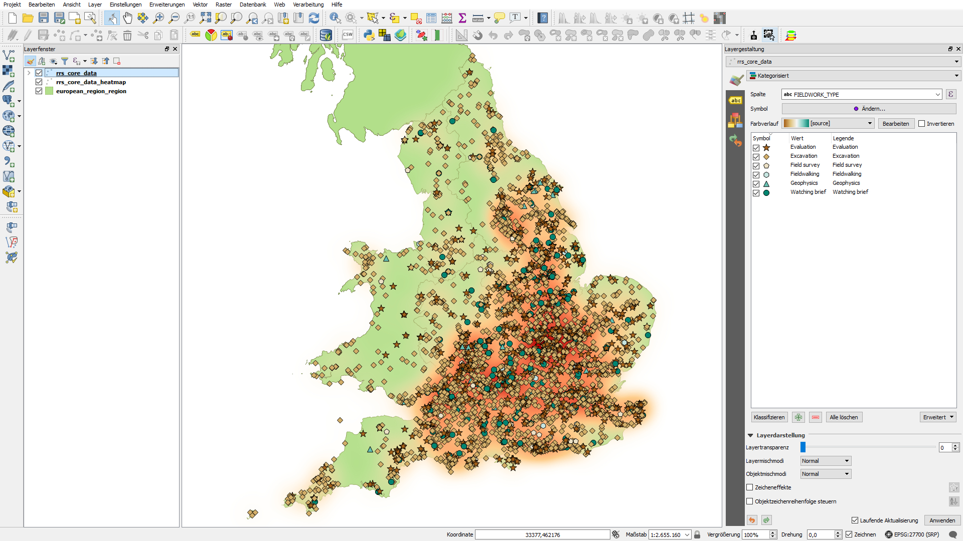
In case of the ‘Rural Settlement of Roman Britain’ dataset the students had to classify selected spatial data of different fieldwork types and generate a simple cartographic visualisation based on these data. Through mastering this task, the students managed to create their first maps in QGIS and carried on with further questions on the distribution of research activities related to the former Roman rural landscape of Britain based on the classified data.
This has been the feedback for this task by student Fabiola:
‘It makes you feel like you are working as a real scientist when you create your first map. With an useful introduction about the data resource and a given overview we didn’t only download some data, we also got to know what it was to work with them and how they have been collected. It is a great opportunity for students that the ADS provides their data openly for the public to download and re-use it. Our task was to learn how to use archaeological data for a GIS and yes, we learned how to do it.’
Future Prospects
Because of the amount of diverse data preserved at the ADS and made made openly accessible by the original data creators there are plenty more chances for students to make their first steps in working with archaeological data. New datasets are uploaded regularly to the ADS which means that the data pool is constantly growing and new features like 3D data visualisation at the website are introduced and evaluated. Not only data for Roman rural settlements in Britain are available but also data for hominin sites in Africa (Predicting the Location of Hominin Sites in Africa and Asia by Matthew Collins, Kathryn Holmes, and Katherine Robson Brown) or artefacts in Roman Military forts in Germany (Engendering Roman Military Spaces by Penelope M. Allison). Hence, in the case of digital teaching and learning and beyond many well-documented deposits are waiting to be explored and re-used.
References and ADS collections mentioned in the text:
Martyn Allen, Nathan Blick, Tom Brindle, Tim Evans, Michael Fulford, Neil Holbrook, Lisa Lodwick, Julian D Richards, Alex Smith (2018) The Rural Settlement of Roman Britain: an online resource [data-set]. York: Archaeology Data Service [distributor] https://doi.org/10.5284/1030449
Penelope M. Allison (2012) Engendering Roman Military Spaces [data-set]. York: Archaeology Data Service [distributor] https://doi.org/10.5284/1017082
Matthew Collins, Kathryn Holmes, Katherine Robson Brown (2005) Predicting the Location of Hominin Sites in Africa and Asia [data-set]. York: Archaeology Data Service [distributor] https://doi.org/10.5284/1000342
Oxford Archaeology North, Historic England (2015) A Viking-age cemetery at Cumwhitton, Cumbria. [data-set]. York: Archaeology Data Service [distributor] https://doi.org/10.5284/1031499
Peter Kraker, Daniel Dörler, Andreas Ferus, Robert Gutounig, Florian Heigl, Christian Kaier, Katharina Rieck, Elena Šimukovič, Michela Vignoli, Edeltraud Aspöck, Sebastian Dennerlein, Asura Enkhbayar, Gerda McNeill, Nora Schmidt, Gregor Steinrisser-Alle (2016) The Vienna Principles: a vision for scholarly communication in the 21st century (version 1). Vienna: Open Science Network Austria https://viennaprinciples.org/v1/ (2019-02-22).