Content warning: This blog post contains images of human remains.
During my MSc in Digital Archaeology at the University of York in 2022, I decided that I wanted to take part in a placement to learn how to apply the digital skills I was gaining as part of my course. With both an MSc and PhD in bioarchaeology, I looked for a role that could combine my previous osteoarchaeological expertise with digital heritage. I met with a Digital Archivist at the Archaeology Data Service (ADS) and she introduced me to the HS2 project. She explained how, as part of the excavations, multiple cemeteries had been uncovered and a large volume of digital bioarchaeological data had been deposited with the ADS in the form of 3D models of in situ burials. The ADS had not yet disseminated an archive like this, and was looking to explore the most ethical and accessible way to do so.
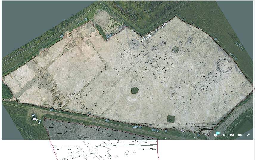
My placement and subsequent MSc dissertation focussed on the Anglo-Saxon cemetery excavated at Wendover Green Tunnel, Wendover, Buckinghamshire. The archive included:
-
- Six GIS data layers
- 5,225 site photographs
- 3D photogrammetric models of 145 inhumation/cremation burials as well as source images, processing reports, and metadata
- 137 .pdf scans of original drawings of specific excavated features
- 17 .pdf scans of original context sheets and indices
- An Excel spreadsheet summarising information gathered about the excavated individuals
- Four official site-specific .pdf reports
- Metadata for the deposited data
As part of the ADS’s standard procedure, all of this data would be available for download through their website. For each of the 145 3D models, the ADS’s standard 3D protocol would include a browser-based viewable 3D model (Figure 1, A), zipped versions of the 3D model files (Figure 1, B) and source images (Figure 1, C), the metadata for the model (Figure 1, D), and the processing report for the creation of the model (Figure 1, E).
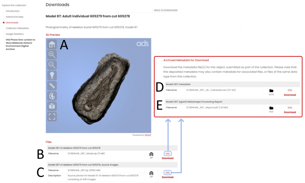
An individual skeleton contains links to almost all of the data types listed above. For example, Individual 605279 from Wendover Green Tunnel and/or their grave cut was:
- Represented by Model 87 (Figure 1, A)
- Recorded in original context sheets (grave cut, skeleton, grave fill)
- Photographed for general excavation records 28 times
- Photographed for photogrammetric purposes 439 times
- Included in the post-excavation spreadsheet (with information about small finds, orientation, preservation, completeness, adult status, presence of pathology, etc)
- Represented by polygon data as an excavated feature and had associated point-based data (skeletal height, photogrammetry points, etc) in the GIS files
Following the standard procedure for 3D model dissemination (see Figure 1), an ADS user wishing to find a specific individual’s location within the cemetery, associated context sheets, excavation photographs, or osteological data would need to do a considerable amount of perusing of the data to locate the information they needed.
Based on the results of my MSc dissertation, which investigated how potential ADS users preferred to be presented with 3D bioarchaeological data (e.g., 3D models/images of human remains), it was clear that a large majority (94%) believed that contextualisation of 3D bioarchaeological models was essential. In order to maximise the desired contextualisation, part of my MSc research involved manual linkages of excavated individuals from Wendover Green Tunnel with their associated archaeological data (i.e., excavation photos, context sheets, drawings). This was a long, drawn-out process which included the following:
- Perusing the .pdfs of original context sheets to identify the page numbers of the context sheets for the associated grave cut, fill, and skeleton for each of the 145 3D models
- Using the captions included in the raster metadata spreadsheet to identify which excavation photos were associated with which individual/model
- Glancing through the .pdf versions of the original drawings to identify relevant grave-related drawings
- Determining a centroid coordinate for each burial using the GIS files and a considerable amount of data manipulation to create a useable format for the specific task
- Using the post-excavation spreadsheet to collate all provided information about each individual (e.g., preservation, completeness, age, sex, small finds)
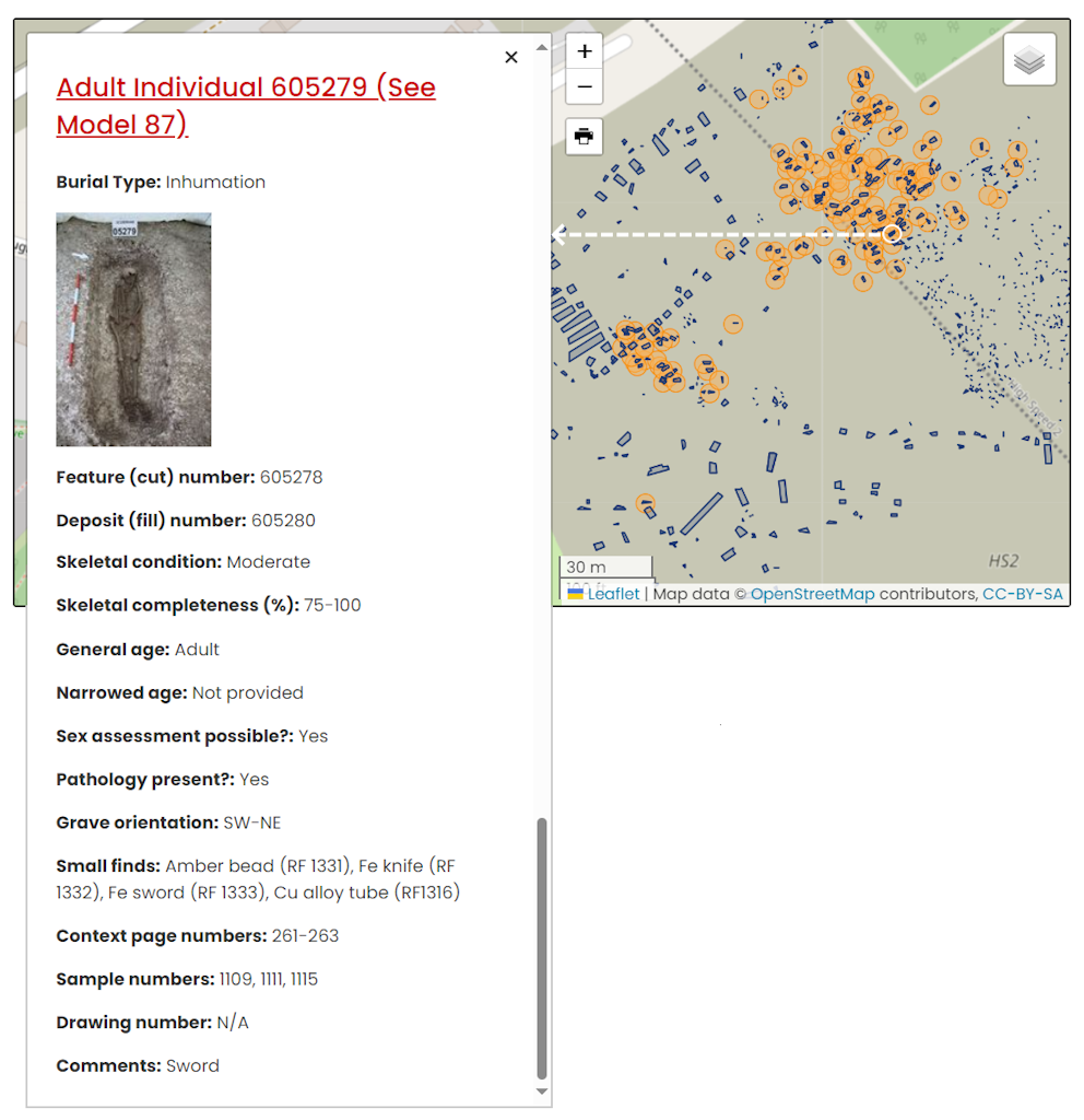
The webpage for each 3D model from Wendover Green Tunnel now contains links to associated context sheets, drawings, and excavation photos. An interactive map was created using the gathered coordinates that has clickable points for each excavated individual and a sidebar that includes the information gathered from the contextualisation process (Figure 2). This contextualisation helps remind users that the image/3D model of the excavated individual isn’t just a floating, un-associated entity, but that it represents a once living human being who was excavated by archaeologists and that such recording and subsequent post-excavation analysis can reveal information about their existence.
Although the above process was time-consuming, the output was a positive step towards ethical dissemination of digital bioarchaeological data. It was decided that similar archive-specific procedures would be undertaken for other HS2 cemeteries. Over 3,000 and 450 3D models from St. Mary’s Church, Stoke Mandeville, Aylesbury, Buckinghamshire and Fleet Marston Cottages and Putlowes, Aylesbury, Buckinghamshire were deposited with the ADS respectively. Given the magnitude of performing manual linkages for such a large number of individuals, the adopted procedures were scaled back when appropriate and were archive-specific. As the primary person performing these intensive contextualisation processes, I have compiled a list of areas where I ran into difficulties and suggestions for how depositors can provide data in a format that makes the creation of such an interactive map more efficient if they wish to disseminate their data in that way.
1.GIS data
Identifying which polygon or point in the GIS files was associated with which grave or skeleton was particularly tricky for some archives. To make this process more efficient, in the polygon layer that demonstrates excavated features, depositors can ensure that there is a clearly labelled attribute for the context number for each polygon (Figure 3, A), and, if possible, an attribute for the associated skeleton number (Figure 3, B). Sometimes the grave cut and associated skeleton, fill, and coffin (if present) are assigned a group number at the time of excavation. This group number is also very helpful to include as an attribute (Figure 3, C). Please ensure these attributes are filled out in a standardised format so that it is simple for the archivist to determine which polygon or point belongs to which skeleton or grave. The coordinate for the skeleton/grave will be determined from the provided GIS data, and this will provide the location for that skeleton/grave on the disseminated interactive map (e.g., Figure 2). It is also helpful to group all of the grave-related polygons into a dedicated burials layer (Figure 3, D) so they are easy to filter out if the GIS file contains all features for the entire excavation.

2. Raster metadata
To better contextualise the 3D model of a burial, it is important to associate that model with the photos that were taken during excavation. These might include an overall grave shot, but also close-up shots of grave goods, features, or pathologies that were considered important to record by the excavator. All raster images deposited with the ADS must be described in a metadata template (completed example). In order to link each model with its associated excavation photos, the archivist must use this metadata to identify relevant captions and keywords. To make this process more efficient, depositors should include the context number and skeleton number within the caption (Figure 4) so that the find function can be used to quickly locate relevant photos. Additionally, subject keywords should be filled in for all raster image files. For photographs including human remains, a set of standard keywords should be used which might include grave, burial, inhumation, cremation, skeleton, coffin, or human remains.

3. File naming
One of the issues I came across that can be easily remedied is file naming. File naming conventions are described within the Instructions for Depositors; it is important that each file name is unique within an archive. Additionally, for 3D models, it is preferable that a 3D model (along with its associated orthophoto, model files, source images, and metadata) is assigned a name that reflects what is in the model. Sometimes we receive 3D models that have very generic file names like “Model 1”. Instead, we request that the file name includes reference to the context/feature that is actually depicted by the model so that it is easier to link with associated data (Figure 5).

4. 3D Metadata
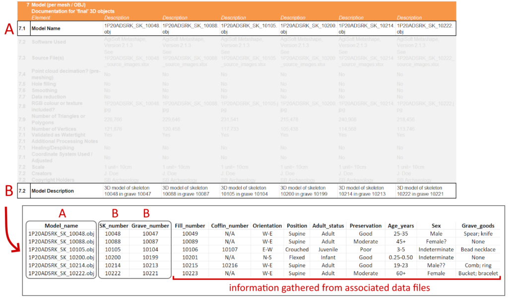
3D data and its metadata are inherently complex. All 3D data deposited with the ADS must be described in a metadata template. When an archive contains multiple 3D models, it is helpful to include the model file names and model descriptions on the same sheet (Figure 6, top) within the 3D metadata template. This allows the archivist to easily manipulate the data to create a spreadsheet which simply links 3D model name with the context depicted in the model (Figure 6, bottom). The image on the bottom of Figure 6 will be the data that populates the interactive map, and provides contextualised information when the user clicks on a specific individual (as in Figure 2).
If a deposited archive contains a large amount of data or 3D data pertaining to excavated human remains, it is suggested that the depositor speak with an archivist early on in the deposition process to decide how to disseminate the archive in such a way that the human beings who were excavated are presented in a contextualised manner. Communication at this early stage will simplify the archiving process down the line and allow the depositor to consider what information about the excavated individuals they want to highlight.
From personal research experience, I have first hand knowledge of how helpful it is having easy, simplified, digital access to osteological data and images. I therefore highly recommend that depositors depositing large volumes of bioarchaeological data with the ADS consider in advance how they can best make this data accessible and reusable for researchers, commercial archaeologists, and interested members of the public.

