C.3 Case study, recording monuments and events: Throckmorton Airfield, Worcestershire
C.3 Case study, recording monuments and events: Throckmorton Airfield, Worcestershire#
Neil Lockett, Worcestershire Historic Environment RecordThis case study is included to provide an overview of the fixed and dynamic elements of the event-monuments-source data model. The process of investigating a real site over a period of time is described, as is the process by which HER records were created and amended. Event, monument and source records are described in more detail in later sections of the manual; the purpose of this section is to set the scene.
Describing the site#
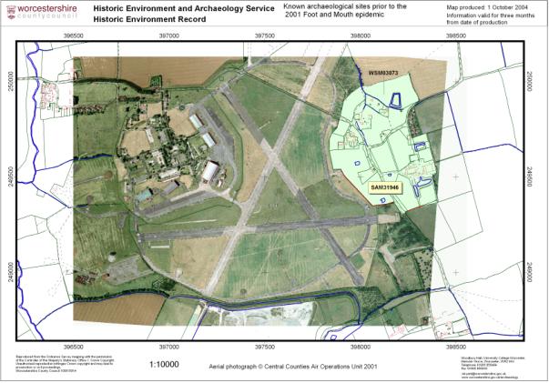
Throckmorton airfield is located on a natural plateau between the villages of Throckmorton, Lower Moor and Upper Moor. The site was identified as a suitable location for mass burial of animal carcasses during the outbreak of foot and mouth disease in April 2001.At the time that the site was identified, only two monuments were recorded on the HER within 1km of the airfield. These comprised the suspected extent of a medieval village and a moated site to the east of the airfield. (Figure 11)
 |
In order to assess the potential archaeological impact of the excavaton of pits for selected for mass burial, aerial photographic sources topographic sources and placename evidence from a 18th century Enclosure map were consulted (Figure 12),. These sources suggested that the extent of archaeological deposits was much wider and of a more diverse character than had been was then known. The placenames ‘Hurstpit Ground’,‘Lower Blackpits’, ‘Ridgeway Ground’, ‘Upper Blackpits’ and ‘Grainway Ground’ shown on an 18th century Enclosure map (Figure 12) extended east to west along the ridge and were suggestive of pre-medieval activity.
An archaeological assessment by the Curator, taking all available evidence into account, suggested that the site had a high likelihood of producing deposits of Prehistoric to Medieval date, with a focus of settlement lying directly under the airfield. It was decided that the potential of the site was such that a formal programme of recording was required during groundworks. This took place in three stages (Figure 13):
- The first stage took the form of salvage recording and watching brief undertaken during the construction of the burial pits and ancillary works (Stage 1, WSM30519, Figure 13). The latter included excavation of a major ‘cut off’ canal and topsoil stripping. This led to the identification of an area of well preserved and significant Romano-British deposits which were rapidly recorded as far as circumstances permitted.
 |
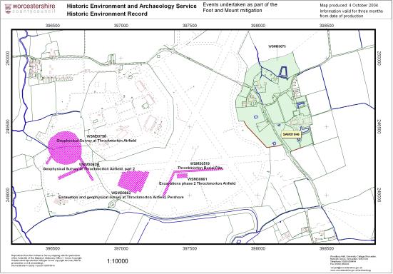 |
- The second stage of work comprised evaluation (Stage 2; WSM30861) of areas of the site under consideration for further burial pits to further investigate significant deposits identified during the early part of Stage 1. Areas of the site to the north, east and west of the initial burial pits were selected for geophysical survey, the results of which led to the removal of selected areas from any contingency plans for additional burial pits in the event of the outbreak continuing. In addition, a further contingency area for two more burial pits was identified. This was sandwiched between excavated burial pits to the north and west and the ‘cut off’ canal to the south and east. A large evaluation trench was excavated to assess the character, preservation and significance of archaeological deposits at this location in order that contingency plans might be devised for the archaeological excavation of the area in the event of the outbreak continuing or a new outbreak developing.
- The third stage of work (Stage 3; WSM30862) was undertaken as a result of the making of a Channel 4 Time Team programme by Videotext Limited. Through the kind co-operation of the landowners, QuinetiQ, an extensive geophysical survey and programme of small-scale trenching was undertaken across one area of significant remains identified by geophysical survey during Stage 2.
As a result of the three stages of work an extensive area of previously unsuspected Iron Age and Romano-British settlement has been recorded. In addition, work by the HER and the Curator enabled the HER record for this part of the county to be substantially improved through desk-top assessment. Analysis of aerial photographic sources, as well as Enclosure and Tithe maps, enabled areas of medieval settlement and cultivation to be more accurately mapped.
Monuments Recorded#
- Neolithic to Iron Age trackway (Documentary / Cartographic evidence)
- Iron Age to Roman settlement (Sub surface deposit)
- Shrunken medieval settlement (Earthwork evidence)
- Medieval field systems (Cropmark / Earthwork evidence)
- WWII to Cold War Airfield site (Extant Building / Structure)
