As training officer for Oasis in England I joined LinkedIn in 2012 & it very quickly became apparent that many potential contacts worked for organisations not then registered on Oasis. Once contacts had been made on LinkedIn I sent a standard email offering free training sessions in Oasis, giving more background to the Online Form & potential lodging of reports in the ADS Library. Many replies were received & training visits made. One memorable trip was made to Long Buckby in Northamptonshire to register Iain Soden Heritage Services on Oasis. Another great advantage of LinkedIn was found to be the notable number of scientific and architectural contacts made. This initiative is ongoing & in the last week some new invites have been sent out. A new discussion group ‘Oasis Forum‘ was also set up on LinkedIn this year.
Monthly Archives: April 2018
Developing the OASIS Form for Northern Ireland
Jenny O’Brien + Louisa Matthews April 2018

In late 2017 we were incredibly pleased to hear that the Department of Communities, Historic Environment Division, Northern Ireland, were ready to implement a long-standing ambition to join-up to OASIS. It was felt that OASIS could help realise several goals set as part of their wider look at the management of archaeological archives and licencing of excavations in Northern Ireland. These goals included adding more structure and consistency to data generated during the course of investigations, and integrating this information into existing systems (and obviously, the dissemination of grey literature!).
At the start of 2018 the ground work had been prepared and Jenny embarked on coding a Northern Ireland instance of OASIS. Here’s how she got on…
Adding the Northern Ireland-specific forms to OASIS was a fairly straightforward process as similar had already been created for Scotland and Wales. The linear three-stage process, by which the information was passed from contractor, to local government validation, to national level validation, was also kept the same.
Of the five main areas of the form (Project Details, Project Location, Project Creators, Project Archives and Project Bibliography), three required alterations to the way the form appeared or behaved: Project Details, Project Location, and Project Archives.
Project Details

The form of the project details page remained the same as for the other countries; it was the word lists that needed changing for this section. For most of the controlled lists, such as the ‘Type of project’ or ‘Site status’, the lists were generated by amending current database tables to indicate the terms that were applicable to Northern Ireland. The main alteration was to the Period table, where a new table had to be created that had the period-date relationships for Northern Ireland as well as the slightly different period-date relationships for the other countries.
Project Location
The Project Location section was, as expected, the area of the form that needed the most work. The Northern Irish location options differed from the other countries in that there was a single ‘Local Council’ level location, rather than the ‘County’, ‘District’, ‘Parish’ sub-divisions seen in the English version of the form. A new table was added to the underlying database to hold the location information including a second level to differentiate between ‘Terrestrial’ or ‘Maritime’ projects. In this case, ‘Maritime’ being treated just as another location sub-division, rather than being used to inform multiple Historic Environment Records (HERs), as the Northern Ireland projects would all be validated by the Historic Environment Division, regardless of the area type or Local Council. The option to select the main and additional HERs was therefore removed, with the validating body set at Historic Environment Division for all Northern Irish records.
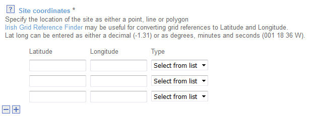
The ‘Site Coordinates’ aspect of the form also needed to be altered substantially from the other countries, being the only country that does not fall under the OSGB coordinate system. Rather than having multiple options to allow users to enter Lat/Long and/or OSGB coordinates here, the default was set to Latitude and Longitude. The functionality which automatically converts the coordinates from OSGB to Lat/Long upon saving was also completely removed in the Northern Irish forms.
Project Archives
This section required the smallest change, with the field heading ‘Archive recipient’ being changed to ‘Archive location’ in all headings and drop-down list defaults.
Finishing touches
Once the main areas of the form were completed and functioning correctly, the rest of the form needed to be checked for country-specific references, right down to the help text, such as that used for the bibliographic information, these were changed to incorporate Northern Irish examples.
The Northern Ireland additions have now been transferred to the live version of the form and are ready for testing.