The development of CAD
Computer-Aided Design software is used worldwide by designers, architects, surveyors and others. It is used in a wide range of applications, from producing development plans for construction or industrial prototypes in manufacturing to producing visual effects in games/films or describing vehicle movement in traffic accidents. Within archaeology the use of CAD has included building and site recording, archaeological survey, interpretative modelling, visualisation and reconstructions.
There are several important reasons to consider using CAD:
- The use of layers in a CAD model makes it possible to record and organise complex material in a way which supports numerous ways of presenting the information visually. For example, thematic layering of a landscape or site, by period or feature type, enables specific characteristics to be presented in isolation from a mass of otherwise complex and visually overlapping drawing objects.
- CAD models can be rotated to view a structure, object or site from different aspects. Three-dimensional CAD models provide an essential framework for any recording of complex spatial information and as such allow the viewer to explore the model from viewpoints which may not normally be experienced in situ.
- Dimensions of objects and coordinates of data points may be retrieved from a CAD model with the same precision used to take the original measurement, whereas in a scaled drawing the original measurements have to be re-calculated. Measurement data held in digital form may also be projected into alternative coordinate systems or site grids with ease.
- Data may be attached to items in CAD models, making the combination of CAD model and textual data more powerful than either alone.
- CAD files may be used by many other program types, such as GIS and virtual reality programs, to provide the base data for other applications.
CAD can be used to create simple drawing objects or more complex two-dimensional or three-dimensional models. This section will look at:
- How CAD has developed
- Important CAD features, layers, wire-frame, surface and solid models
- Rendering surfaces
- Multiple CAD files and connected data tables
- Differences between CAD, drawing programs and virtual reality
- Relationships between CAD and GIS
- Examples of how CAD has been used at the Acropolis in Athens, Deansway in Worcester, Symon’s Castle in Powys and the York Minster.
How CAD developed
CAD programs initially mimicked the world of two-dimensional paper drawings, but with the advances in both computer hardware and software, designing in three dimensions has become commonplace. CAD programs have an interesting parentage that helps to explain why they work as they do and which has bequeathed specific qualities to contemporary users. In fact ‘Paper Space’ is still used in CAD terminology to describe the two-dimensional presentation space for organising the plotting and printing of CAD models.
Paper drawing conventions
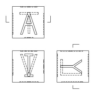
Paper drawings of objects are two-dimensional representations of the real world and such technical drawings use a series of conventions. For example, engineering drawings generally show the front, right side, and top of an object (see Figure 1). Broken lines are used to indicate lines that are hidden in the particular view, another line type is used to indicate the centre of a circle, another for the longitudinal axis of a cylinder and so on.

Pin-bar drafting
A process known as pin-bar drafting was developed by architects to permit convenient draughting of multi-storied or very complex buildings. Multi-storied buildings have identical exteriors for many floors but might have different interiors. Similarly, complex buildings, whether multi-storied or not, required separate electrical plans, plumbing plans, plans for heating and air-conditioning ducts, and so on. To eliminate duplication of effort, architects could draw the structural outline of the building (and common features like elevator shafts) on one sheet of paper, position a transparent sheet over the base sheet (on registration pins, hence the term), and then draw the interior of a specific storey on a transparent overlay. In the same fashion, electrical diagrams, plumbing diagrams, and so on could each be put on a transparent sheet, and a large number of such individual overlays could be put together on the registration pins so that many drawings could be viewed at once – making all features or only a few visible at one moment, as required.
Computer-assisted drafting and computer-aided design
Computer-assisted drafting (CADD) programs were developed for architectural use and featured capabilities such as layering, mimicking the transparent overlays used in pin-bar drafting so that traditional architectural practices could continue.
Computer-aided design (CAD) programs were developed for engineering, to make it possible to move directly from product design specifications to manufacturing and to permit the visualisation of products in advance of production.


