Georeferencing and data combination
To compare geophysical data with other data sources (e.g. aerial photographs, earthwork surveys, adjacent excavations) or data recorded on different alignments, all data have to be converted to a common map coordinate system and datum (e.g. WGS84, OS Coordinates, site grids). This requires detailed spatial information for all data sources.
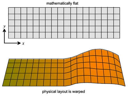
Geophysical data that were collected on regular grids or along lines are usually defined in a rectangular and homogeneous coordinate system, the geophysics coordinate system, which is defined irrespective of any topographic changes. To achieve the best possible fit with other data that are usually projected onto a horizontal map plane they may have to be warped to adjust for topographic distortions. However, in many cases a simple restricted affine transformation (shifting, rotating, but no stretching) is sufficient. The accuracy of the georeferencing determines the accuracy with which a particular geophysical anomaly can be located on the ground, for example for subsequent excavation. It is important to remember the difference between the mathematically defined rectangular geophysics grid coordinates (lines and measurement points) and the projection and warping onto physical map coordinates (see Figure 7). More information on coordinate systems and coregistration is provided in Appendix 2.